Showing posts with label Balloon. Show all posts

Tuesday, July 28, 2015

High above Colorado

The Rocky Mountains and Boulder, Colorado
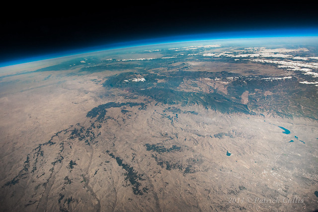
  I've been going back over some of the photos from my balloon flights the past few years and started wondering if I could stitch a few of them together in to a panorama.  Turns out, yes I can!  I can barely believe how well they are turning out.  If you follow the link to my Google+ version it will allow you to zoom in and look around at everything.
Detail visible in Boulder and the Flatirons when you zoom in.

Silverthorne, CO and Dillon Reservoir.  Coming from the lower right is I-70 heading up to the Eisenhower Tunnel and the split off for Loveland Pass. To the left you can see the ski slopes of Breckenridge.  Behind Breck is Copper Mountain, and it's not as clear, but Vail, the wide open back bowls, and blue sky basin.
Berthoud Pass on the way to Winter Park and Mary Jane is one of my favorite bits.
Barker Reservoir and Nederland, Colorado up in the foothills from Boulder.  A bit further up from Ned is Eldora (town and ski area) and Indian Peaks Wilderness Area.

Launching an Ozonesonde from Boulder
Everything better be secure.  Burst is not gentle...
This one didn't even hit the ground!
"Moon Balloon"
   A couple of years ago I did another flight in order to capture the moon above the haze of our atmosphere.  I made a video of that launch from some GoPro footage and some other small cameras.
Balloon Flight from Patrick Cullis on Vimeo.
Video and photography from two high altitude balloon launches from Boulder, Colorado. Views of Boulder, Denver, and the Continental Divide from over 85,000 feet as well as video of launch and burst.  This video was from an earlier balloon flight where I was launching in order to capture the moon near the horizon after the package had made it above the bright glow of the atmosphere.  Out of roughly 700 images, the moon was in a grand total of 3...

The balloon bursting at over 100,000 feet!
  The balloon starts out roughly six feet across, but by the time it gets to 100,000 feet it is almost 30 feet in diameter!  This sequence of four images is from a GoPro running at 48 frames per second.

GMDDaytime-71
Launching an ozonesonde balloon at the South Pole in 2009
  I learned about launching balloons working for NOAA measuring the ozone layer.  One of the trickiest places to launch balloons is at the South Pole while measuring the annual formation of the Antarctic Ozone Hole.  I wintered over during the 2009 season and during the six months of darkness the rubber balloons are unable to stretch without the warmth of the sun shinning on them.  We must instead launch the instruments on large plastic balloons. 

  My website: www.PatrickCullis.com
  I have more images from above Colorado at my page on High Altitude Balloons.
  Night photography from Antarctica are here:
  Photography of Boulder's iconic Flatirons are here:

Warning:  I have read the FAA regulations on free flying balloons many times and they are very specific about size, density, and weight restrictions.  If you want to fly a high altitude balloon, please be sure that you are not breaking any laws. 

Friday, September 26, 2014

Going Leafing...


  I flew my camera on another balloon this week to try and capture the Aspen leaves changing up in the mountains.  It was pretty excellent conditions and I think I got some good stuff!  This photo is from 95,000 feet above Floyd Hill.  We had to hike a little ways, but it was well worth it.


  I also had my GoPro taking video of the balloon when it popped and got some incredible images of the latex balloon bursting.  My favorite is the one where it just starts showing the first sign of popping, but most people prefer the later ones when it really gets shredding.  The latex dust "sphere" left behind is also pretty cool.

Sunday, July 20, 2014

PotD #003

PotD-003
  The Southern Colorado Front Range looking towards the Black Forest and Colorado Springs, and the snow-capped rocky mountains, including Pike's Peak in the isolated collection of snow-capped peaks!

Monday, February 10, 2014

High Altitude Balloon Flight


Balloon Flight from Patrick Cullis on Vimeo.

  A short video compiling footage from two balloon flights last summer.  Includes high resolution photos from above 85,000 feet as well as video from launch, burst, and landing.

  Music by Excavacations - Actual Behavior

Thursday, June 27, 2013

Take the Highway... (to the Moon over the Great Divide)

The Moon sets above the Great Divide from 86,000 feet above Colorado.

  The snow-capped Rocky Mountains of Colorado stretch across this photograph taken on June 27, 2013 from 86,000 feet.  The waning Moon shines in the black sky above the Earth's thin atmosphere.  I-70 snakes up from the bottom towards Loveland Pass and the Eisenhower Tunnel.
The Moon above the Rocky Mountains of Colorado.
Dillon Reservoir, I-70, Georgetown, Berthoud Pass, and Winter Park / Mary Jane
  In the center of the photo can be seen (from top-left to right) Dillon Reservoir in Frisco, CO, I-70 snaking down from the Eisenhower Tunnel to Georgetown (in valley stretching from left to right,) and Berthoud Pass to Winter Park Ski Area in the top right.

Lake Granby and the Continental Divide

Denver and Boulder from 86,000 feet.  
  From a view looking northeast, the sprawl of Denver can be seen in the bottom right.  Nestled against the foothills and iconic Flatirons, Boulder is on the left, below center.

Monday, June 24, 2013

Go Higher

Boulder, Colorado and the Continental Divide from 100,000 feet.
 Snow-capped peaks highlight the Continental Divide while smoke from forest fires fill the valleys.  I'm hoping to get a clear day soon for a follow up, but may have to wait until winter to get a transparent air mass.

Sunday, February 10, 2013

Fantasy Canyon

Rock formation at Fantasy Canyon in Utah
  I went out to Venal, Utah for work and was lucky to be able to photograph an amazing formation in the Uintah Basin.  Fantasy Canyon is a pristine piece of beauty tucked away inside the vast sprawl of Utah's oil fields.  We were there measuring winter time ozone levels which have hit some amazingly high numbers over the past several years, and I had some free time to set up my cameras while the data came down. 
Fresh Powder on Fantasy Canyon
  We first found out about the small state park because of a curious mind and a brochure in the Vernal Airport Enterprise Rent-a-Car. 
  We were given permission to run a tether in the parking lot of the Canyon for vertical ozone and meteorological profiles.  The Uintah Basin is surrounded by three ranges of mountains which trap polluted air inside of it like a fish bowl.
Measuring Ozone from a Tether

Chance suited up for a cold afternoon.
Balloon above Fantasy Canyon
Fantasy Canyon from the balloon
  For one run I actually attached my helmet camera to the balloon in order to get some better views of the surrounding landscape.  The "canyon" consists of the eroding rocks seen just below and left of center.

I see a mayan chieftain in this silhouette.
  I worked the afternoon shift at the canyon several times and was treated to some pretty fantastic sunsets.  It felt wonderful out there in the sun, but as soon as it set, temperatures dropped in to the single digits.

  
Ozone Balloon joins Jupiter and the Pleiades
Witches Head and Three Dogs at night